![]()
![]()
![]()
![]()
![]()
![]()
![]()
![]()
![]()

Texas Trail Maps
The trail mapping project currently under development by SGI, and in conjunction with DORBA (Dallas Off Road Biking Association) began in the Summer of 2005. SGI is pleased to be associated with a group such as DORBA, who has worked hard to develop and maintain superior biking and hiking trails within the Greater Dallas/Fort Worth Area. SGI began this prototype project, to further push the boundaries of our knowledge in GIS and GPS mapping. This project will be growing in size to develop high quality trail maps for all the DORBA trails in the metroplex, as we continue to expand the possibilities of this innovative technology.
For information about this trail mapping project, please direct questions to:
Michael Salcedo
misalcedo@salcedogroupinc.com
(214) 941-8610
Windmill Hills
Preserve - 11" x 17"
(4.0 mb)
Located in Dallas
County, within the City of Desoto.
![]()
Windmill Hills Preserve Aerial
Map
Boulder Park
- 11" x 17"
(7.2 mb)
Located in the City of Dallas, a nice rocky park in the city.
![]()
Boulder Park Aerial Map
Click on the links to download a .pdf version of these maps.
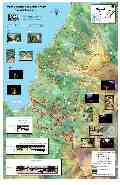
Cedar Hill State
Park - 11" x 17"
(7.2 mb, and 4.9 mb)
Located in Southern Dallas County
on the shores of Joe Pool Lake. This map depicts the new trails as they
exist today.
![]()
Cedar
Hill State Park - Aerial/Profile Map
Cedar
Hill State Park - 3d Animation (5.4 mb)
This map depicts
the trails as they were before the large re-alignments.
![]()
Cedar Hill State Park - Aerial/Profile
Map
Sister Grove
Park - 11" x 17"
(4.9 mb, and 4.2 mb)
Located in Collin County on the
shores of Lake Lavon.
![]()
Sister Grove Elevation Map